In the early days of glaciology research, studies involved traveling to the glacier (possibly onto the glacier’s surface) and taking measurements and photographs. Methods used to study glaciers have changed dramatically over the years. Just as medical doctors use new technology to assess the health of their patients, Leigh Stearns and other scientists use many different types of modern technology to better understand the ways that Greenland’s glaciers function and are changing. In fact, her work depends on the use of modern technologies.
Researcher: Leigh Stearns, Assistant Professor, University of Kansas, Department of Geology
University/Organization: The Center for Remote Sensing of Ice Sheets (CReSIS) at the University of Kansas
Research Location: Greenland
Leigh first studied mountain glaciers in Sweden and Norway as an undergraduate from Carleton College and moved on to study ice sheets as a graduate student. Now she works as a researcher at the National Science Foundation’s Center for the Remote Sensing of Ice Sheets (CReSIS) and serves on the faculty at the University of Kansas. She is currently focused on understanding changes in outlet glaciers in Greenland, particularly Helheim Glacier on Greenland’s east coast.
The great ice sheet on Greenland is being watched closely because it is home to some the fastest moving glaciers on Earth. Researchers from CReSIS are particularly interested in the behavior of four of Greenland’s glaciers that flow to the sea, called outlet glaciers: Jakobshavn (yah’-cub-shaw-vin), Kangerdlussuaq (kong-ger-loose’-wok), Helheim, and Petermann. These glaciers are located in distinct geographic locations on Greenland’s east, west and north sides and provide insights into how the ice sheet is responding to change. For the past two years, Leigh and her colleagues, Meredith Nettles, (Lamont – Doherty Earth Observatory) and Gordon Hamilton (University of Maine) have been measuring changes on Helheim and Kangerdlussuaq glaciers.

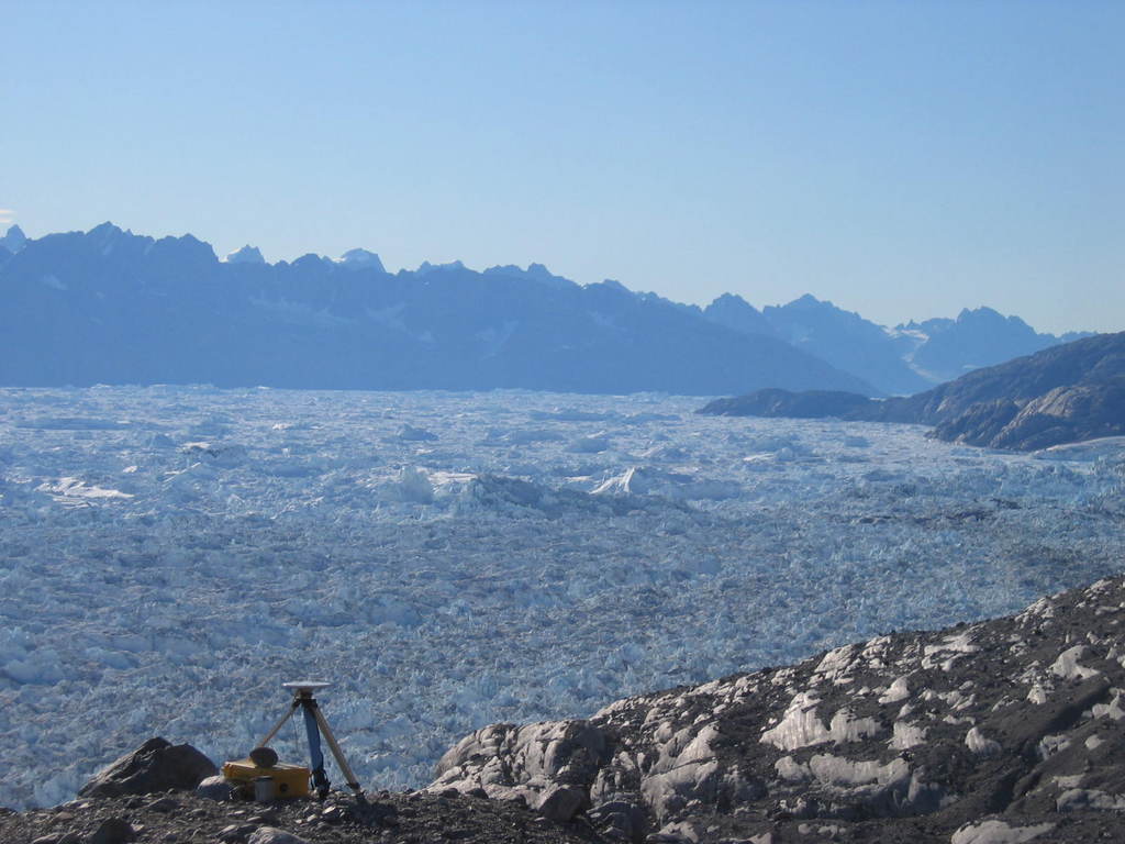
Greenland’s ice sheet studied by CReSIS researchers. Image courtesy of Leigh Stearns.
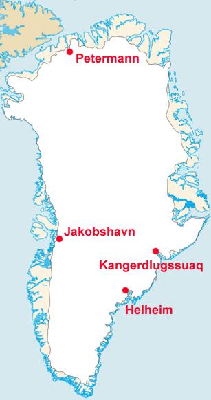
The four outlet glaciers studied by CReSIS researchers. Image courtesy of Leigh Stearns.
As outlet glaciers flow toward the sea, the terminus (lowest end) breaks off, or calves, and pieces of ice float away, becoming icebergs. While we can see such changes with our eyes, and our brains record the memories of what we saw, science depends on measurements. Just as is the case in medicine, technologies that assist and extend our senses are required to assess the nature and rates of change that are occurring.
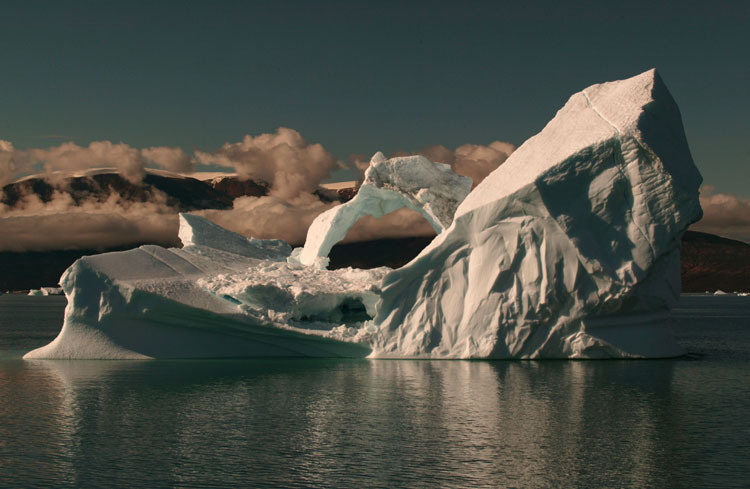
Image courtesy of Leigh Stearns.
Icebergs are interesting, but Leigh and other scientists are more interested in the dynamics of ice flow in general. They are trying to explain the interaction of the ice with the rock or water below, which will help them to explain why, when, where, and how the ice breaks away. Their goal is to predict how the glaciers will change over time and what that might mean for sea level rise. They’re trying to assess what controls iceberg production, and how it differs each year.
HOW DOES ONE STUDY GLACIERS?
Leigh and her team travel to Greenland three or four times a year between May and September to install and check equipment, download and process data from their instruments, and take physical measurements and photographs of the glaciers. They’re usually there for two weeks at a time, but sometimes they spend as little as ten days or as long as four weeks, often dependent on the weather. Some other research groups camp out on the glacier, but Leigh’s team has different kinds of equipment needs. They live in a hotel in Tasiilaq, a town some 60 miles from the glacier. Evenings are frequently spent preparing and double-checking their equipment and processing data.

Helicopters transport researchers to study sites on the glacier’s surface. Image courtesy of Leigh Stearns.
The study sites are on the glacier surface, which is heavily broken (or crevassed), so Leigh’s team relies on helicopter pilots to get to the research sites and find a safe landing place nearby. The pilots are familiar with the area though and, without visible landmarks like trees or buildings, use the known coordinates to locate the sites. As they make their approach, the pilots identify a landing site that is flat enough for the team to work a substantial distance away from the whirling rotors.

Image courtesy of Leigh Stearns.
There are usually one or two helicopters in town, which are used for doctor visits, transporting patients, and general deliveries for the local people as well as working with the research teams. Leigh’s team understands that it is part of a system and must be both prepared and flexible in scheduling flights.
INSTRUMENTS USED FOR RESEARCH
Each season, Leigh and the team install Global Positioning System (GPS) units on the glacier. The GPS unit moves along with the surface ice as it flows toward the sea. Glaciers become thinner as they flow, so each GPS unit provides information about both where it is located and its elevation above sea level. The team’s GPS units obtain positioning information from nine satellites to determine their precise location and elevation. The GPS units enable the researchers to learn the direction and rate of the glacier’s surface motion and its height above sea level.
A GPS unit on the glacier’s surface. Image courtesy of Leigh Stearns.
Every other year, the team downloads data from the GPS units and changes the solar-powered battery packs. The team members have not yet lost a unit, but they have had several close calls. They’ve had to rescue a few that fell into crevasses; once a unit was crushed by moving ice. The units they are using now are less expensive and automatically transmit data with a radio link to a receiver mounted on a rock outcrop above the glacier. But the connection is not always good. As a result, there may still be some data loss, but not nearly as much as would occur if the team lost a unit completely!
Automated weather stations (AWS), maintained by the team’s colleagues from Denmark, are installed at specific locations to provide daily records of temperature, wind speed and direction, and relative humidity on the glacier. Cameras focused on the terminus of the glacier enable scientists to watch calving events and to record the times and amount of ice that breaks free. Cameras also allow scientists to track the direction and rates of movement of crevasses and patches of debris that are visible on the surface of the ice.
This spring and last year, Leigh helped to install instruments to record salinity and temperature measurements in the fjord where the glacier reaches the sea. This information can be used to describe changes in the water flow and will help to explain the role of water movement into the fjord. Tide gauges also help the scientists determine if glacial motion is linked to tidal activity. The tide gauges provide other evidence about when calving occurs because of the wave that is generated when ice falls into the water. The arrival of that wave actually gives better data for calving events than pictures from the cameras, which only take pictures every 5-10 minutes.
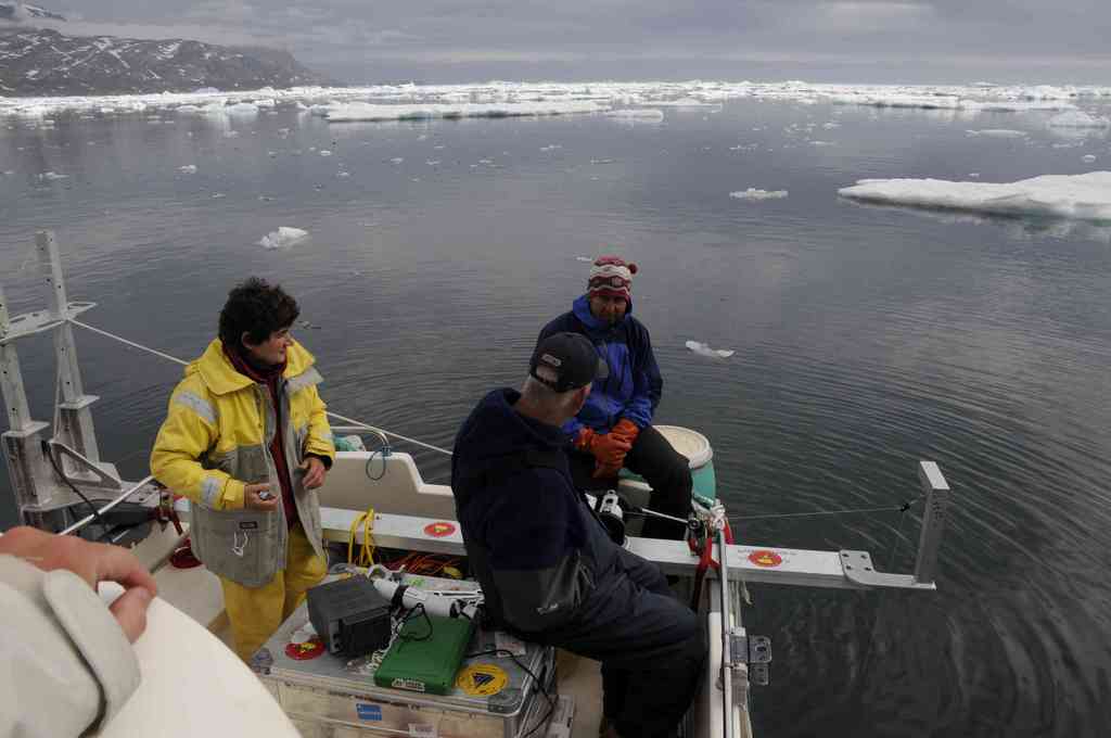
Image courtesy of Leigh Stearns.
DOING FIELD WORK
In addition to the right instruments and measurements, it’s critically important to have a knowledgeable, competent, and experienced team in any field-based situation. Obviously, the team shares a common interest in glaciers and ice, along with actual field experience in Greenland. But the team has specialist roles, too. For example, Meredith usually handles more of the logistics and instrumentation, while Gordon and Leigh, who have mountaineering experience, work well together as a coordinated field team.
The success of any mission also depends on being outfitted with and trained to use the appropriate gear. There are some distinct differences in NSF provisions for training and outfitting Greenland and Antarctic teams. Antarctic researchers get their clothing and basic field gear from NSF when they prepare to enter and leave Antarctica from a deployment center, with NSF-supported transportation to and from a field station. NSF also supplies specific equipment, which is checked in and out as researchers deploy from and return to the station.
In contrast, researchers who travel to Greenland fly to the nearest town served by commercial airlines. From there, pre-arranged charters take them to and from the study sites. As a result, researchers who go to Greenland typically buy their own clothing and basic field gear, and the project manager ensures that the necessary equipment has been ordered and delivered. Field teams familiarize themselves with the equipment they will use while they are still at their home site. One of the highest priorities upon arrival in Greenland is to verify that the equipment has arrived and is in good working condition. Another priority is clothing made from lightweight and quick-drying fabrics that wick moisture away from the body.
Conditions on the glacier can be dangerous, and training in survival strategies is necessary. Leigh’s team has harnesses and ice axes but is not always “roped up” like climbers. In the long run, it is safer to be on the ice for a short period of time than to spend the time preparing the ropes.
DOING RESEARCH
Obviously, communication is critically important as the pilot and the team make the ongoing decisions of the day. Maybe they will fly directly to the glacier to download data and change the battery pack, or instead fly to a rock site on the side of the fjord to install cameras. If weather conditions aren’t good for either of those choices, they wait for days with better weather.
The team has well-rehearsed strategies so they can place or retrieve their equipment quickly. They practice being efficient. They know who’s going to do what job and how to do it quickly. With a handheld drill, Gordon will drill holes for the poles on which GPS units are mounted. Meredith turns the GPS units on, and Leigh unloads the poles and installs them.
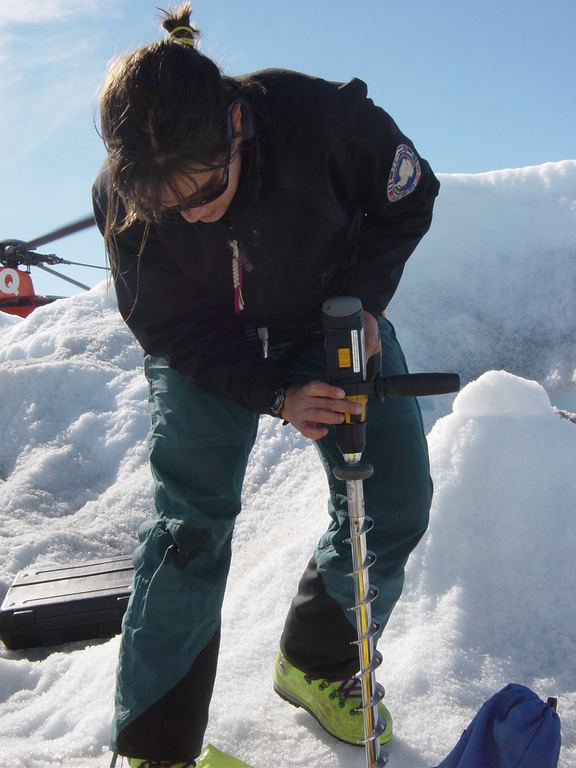
Leigh drills a hole in order to install a pole on the glacier’s surface. Image courtesy of Leigh Stearns.
The poles are at least two meters (6.5 feet) long so that the equipment is well anchored in the ice. When all goes well, the team can install equipment in seven minutes. Because the ice is treacherous, the pilots rarely turn off the helicopter rotors. Instead, the pilots wait while the team works. It is often extremely loud and windy when installing equipment at the study sites!
There have been a few occasions when the helicopter rotor was turned off. At those times, Leigh has heard the rumble of ice cracking beneath her. She said, “It’s amazing to hear all this noise, but not to see anything happening. The noise may be coming from deep in the crevasses or far away.”
LIFE NEAR THE GLACIER
Because Helheim Glacier is located on the Arctic Circle, it isn’t completely dark, more like dusk, early in the summer. Leigh and the team are becoming well known in Tasiilaq. When there’s down time and little to do, she plays soccer with kids in the area or prepares food for the team and their Greenland friends. Obviously, the local people depend on the sea for their food; but pasta, rice, and potatoes are also commonly available. Fresh vegetables are only brought in seasonally. There are times when an apple might cost $10. When Leigh tried to make chili a couple years ago, she was surprised to learn that there were no dried beans to be found. They’re just not a part of the traditional Inuit diet.
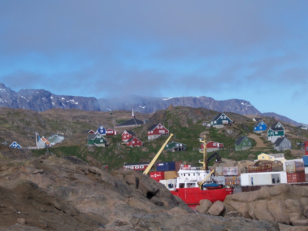
The town of Tasiilaq, Greenland. Image courtesy of Leigh Stearns.
The limited number of flights, due to the weather and darkness, makes it necessary for the local people to plan ahead and to be creative when supplies run low. One year, the school was running low on paper in April, and knew it wouldn’t get more until June! Teachers rationed their remaining supply, and did a lot of work on blackboards.
Interestingly, the glacier has retreated so far up the valley that it is not visible from town. The local residents are no longer able to see the changes in the glacier firsthand.
WHAT IS KNOWN AND REMAINING QUESTIONS
One of the primary improvements in research technology is the ability to get data throughout the year, even when it’s bitterly cold and dark…and therefore treacherous for travel to the polar regions. Some data come from satellite coverage of the Arctic, but satellite data can be obtained only when the satellite passes overhead every 8-11 days. In addition, instruments onboard satellites require ground-truthing, where measurements from “on the ground” are used to verify that the data recorded by instruments onboard the satellites are accurate.
Unlike the instruments onboard satellites, the instruments Leigh and her team have placed on the ice can record data at scheduled intervals (minutes to hours to days apart). They also store their data in devices that are durable and easy to download or retrieve. Improvements to these devices provide a tremendous advantage to the research team.
Leigh’s team has learned a lot about the small-scale changes of Helheim Glacier in the past few years, but several questions remain. In particular, the team would like to know more about how ocean circulation affects glacier flow, and how far up-glacier changes (iceberg calving, for one) can propagate.
Answering these questions will significantly help to explain the glacier system and what causes it to change. Researchers really don’t know anything about what is under the ice at Helheim. Researchers at CReSIS are working to measure the bed topography (the surface of the land under the ice), but it’s also important to know what type of rock or sediment it is made of, and how much water is directly below the ice.
This article was written by Carol Landis and Carolyn Hamilton. For more information, see the Contributors page. Email Kimberly Lightle, Principal Investigator, with any questions about the content of this site.
Copyright August 2009 – The Ohio State University. This material is based upon work supported by the National Science Foundation under Grant No. 0733024. Any opinions, findings, and conclusions or recommendations expressed in this material are those of the author(s) and do not necessarily reflect the views of the National Science Foundation. This work is licensed under an Attribution-ShareAlike 3.0 Unported Creative Commons license.