Can you imagine living on an ice floe for a couple months to track its drift with the ocean currents? What must it be like to set up camp on the ice, with only more ice and icy cold water as far as the eye can see, and watch the ship sail away? Few people have had such an experience, and even fewer of them are women. Yet this is only one of Vicky Lytle’s memorable experiences while studying Antarctica’s sea ice.
Researcher: Vicky Lytle
University/Organization: Center for the Remote Sensing of Ice Sheets at the University of Kansas
Research Location: Arctic Ocean and Antarctica
What set of circumstances leads one to a career of studying ice? Vicky Lytle, who is the associate director of education and outreach for the National Science Foundation’s Center for the Remote Sensing of Ice Sheets (CReSIS), started working with ice in the Arctic but has spent the rest of her career so far studying Antarctic sea ice. Although her formal training was in engineering, she now considers herself a “sea ice physicist.”
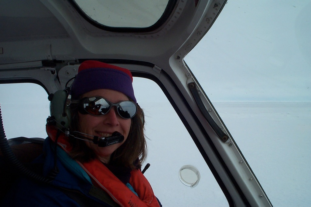
Vicky Lytle en route to an ice floe. Photo courtesy of Vicky Lytle.
Vicky began her icy journey in Alaska. As a petroleum engineer for an oil company on the North Slope and in Cook Inlet, she helped to build ice runways and get ships to oil platforms surrounded by ice. The ice was interesting, and while she was working there she earned a master’s degree in Arctic engineering. Following that, she decided to pursue a Ph.D., which came with an opportunity to go to Antarctica to study the sea ice there.
WHAT IS SEA ICE?
Sea ice forms on the surface of seawater, as the cold air and wind cool the water to its freezing point, around 29 degrees Fahrenheit. This is slightly colder than the freezing point of fresh water – a common characteristic of water containing impurities (such as salt), known as freezing point depression. If there are waves in the ocean, the ice forms floating disks, called “pancake ice,” which eventually freeze to each other, making a more continuous layer of ice. The characteristic upturned edges of the pancakes are the result of bumping into each other as the water moves beneath them.
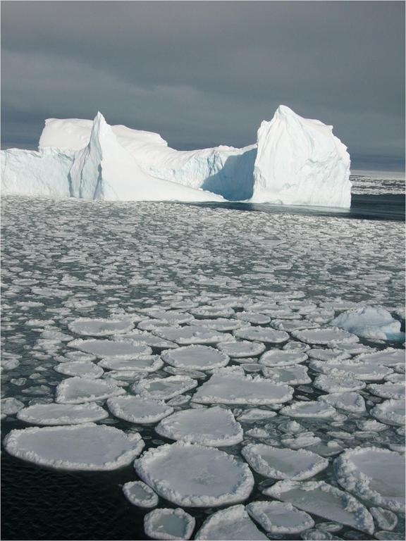
Pancake ice forms when waves are present as the ocean surface begins to freeze. Photo courtesy of Vicky Lytle.
Once a layer of sea ice has formed at the surface of the ocean, additional sea ice forms on the bottom of that layer, where it is in contact with liquid water. Snow can accumulate on the surface of the sea ice. The air temperatures can drop far below freezing in the polar regions. However, this snow-covered ice acts as a blanket, insulating the warmer water from the much colder air temperatures. The temperature of the seawater hovers at -1.8 degrees Celsius. If the air temperature cools the water more than that, more ice forms; if it rises, more ice melts. Scientists study the transfer of energy as the water changes from liquid to solid (and back again).
Although sea ice formed from salty water, it doesn’t have the same salinity as seawater. As an ice crystal forms, the molecules must line up in a specific pattern. Therefore, as the water transforms from liquid to solid, the alignment of molecules in the ice crystals actually excludes much of the salt. In fact, the ice itself is “almost fresh,” except for pockets where the excluded salt accumulates as brine. The brine gradually works its way downward through channels in the ice, increasing the salinity of the water beneath the sea ice. In the summer, when the snow starts to melt on the surface of the ice, the melt water drains through the ice, flushing even more of the salt downward.
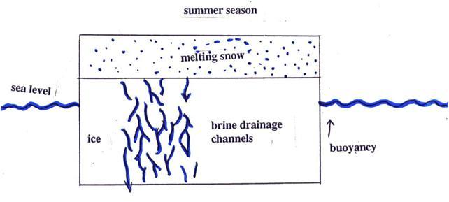
In the summer, melting snow on the surface of the sea ice flushes even more of the brine downward. Image courtesy of Vicky Lytle.
Sea ice is dynamic. Several processes interact to produce the shape, thickness, and condition of the sea ice at any given time and place. The increase in salinity beneath the sea ice causes the denser water to sink, resulting in the deep water formation, which drives the “conveyor belt” (the general circulation of the oceans). Open water at the surface releases moisture into the air, which falls as precipitation elsewhere, and collisions of ice masses cause pressure ridges (small mountains of ice above the sea ice surface) to form.
Separation of sea ice fragments creates open areas where the wind can further chill the water, creating more ice. Ocean currents and winds move sea ice and icebergs (floating pieces of ice shelves from glaciers) in somewhat predictable paths around Antarctica and the Arctic Ocean. All of these factors help to shape the extent and thickness of sea ice in both polar regions.
Climate scientists also study the large amounts of solar energy that are reflected back to space from the polar regions. The reflective characteristic of any surface is known as its albedo. In areas where sea ice forms on open water, the surface goes from a black absorptive surface to a white one that is highly reflective. This is the main reason why the polar regions play such an important role in the changing climate.
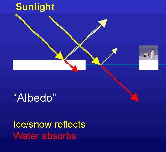
Diagram courtesy of Earth and Space Research: http://www.esr.org/.
WHAT ARE THE DIFFERENCES BETWEEN ARCTIC AND ANTARCTIC ICE?
The primary differences between Arctic and Antarctic ice are location and thickness. Antarctica’s sea ice forms around the edges of the continent, a large landmass that extends north of the 60-degree latitude line. Because of this, the sea ice around Antarctica forms in waters closer to the equator than the sea ice area of the Arctic. There is some amount of second-year sea ice in the Weddell Sea, and in the Bellingshausen, but most of the sea ice in Antarctica formed during the previous cold season and melts during the following austral summer. As a result, Antarctica sea ice is typically less than a meter (39.37 inches) thick.
Sea ice in the Arctic Ocean can be up to 10 times as thick as Antarctic sea ice. This is because the Arctic Ocean covers the North Pole and much of the north polar region. Therefore, unlike the Antarctic, where sea ice forms around the relatively warmer latitudes (60- to 65-degrees South), Arctic sea ice forms all the way to 90-degrees North. Because most of the Arctic sea ice is closer to the pole, there is less solar input. Winter temperatures are typically much colder over Arctic sea ice than over Antarctic sea ice, which forms much farther from the South Pole.
Historically, the Arctic Ocean has had multiyear ice that did not melt completely away in the summer. Therefore, new ice formed under existing ice during the next cold season, resulting in much thicker sea ice than is found in the Antarctic. However, in recent years, some of that “old ice” has melted away. A record minimum area (or extent) of Arctic sea ice was set in 2005, and then last year, a new, much lower ice minimum record was set. We will soon learn whether a new record low will be set for sea ice extent in the Arctic in 2008!
Once the Arctic’s multiyear ice (thicker ice) is gone, the sea ice will be thinner and more like ice in Antarctica since it will have formed in just one year.
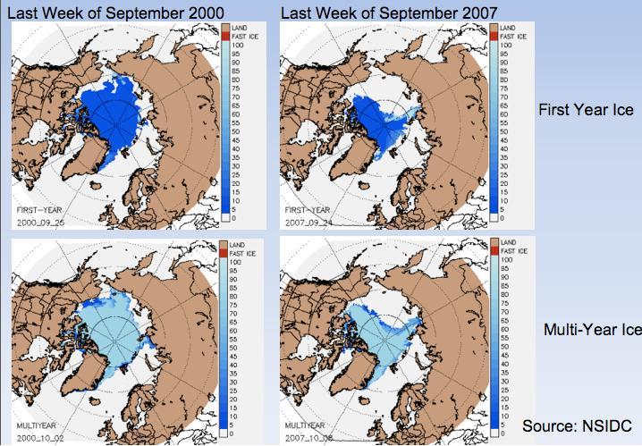
First-year and multiyear ice during the last week of September in 2000 and 2007. Images courtesy of National Snow and Ice Data Center.
HOW DO YOU GET TO ANTARCTICA TO STUDY SEA ICE?
Keep in mind that sea ice completely surrounds Antarctica each winter. In fact, the area of Antarctica more than doubles with the addition of sea ice each year. As a result, how you get there depends on which area of sea ice is being investigated.
Vicky has traveled to different parts of Antarctica to study the sea ice for over 20 years. She has entered Antarctica waters from Punta Arenas, Chile; from Puerta Madryn, Argentina; Montevideo, Uruguay; Cape Town, South Africa; Hobart, Tasmania; and Christchurch, New Zealand. Although she had traveled to Antarctica many times, at one point she realized that she had not set foot on the continent! That was because her work was always done from a ship and often in the middle of winter when it is difficult to get through the sea ice to the continent. Since then she has been to Casey Station, an Australian research station, so she has now visited “Antarctica.”
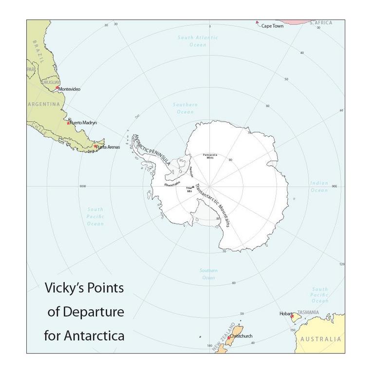
Vicky’s points of departure. Click to enlarge.
Vicky also realized that most of her trips have been expeditions with other countries, rather than with U.S. research teams. Her work is a terrific example of international collaboration.
Her doctoral work occurred at a time when satellite coverage of Antarctica was being expanded. In fact, Vicky recalls the progression of satellite development in recent decades according to the problems researchers were trying to resolve. In the 1990s, the European Space Agency (ESA) was planning to launch a satellite with the capacity to observe the polar regions in all weather conditions, by using an active microwave instrument. It was one of the early satellites that carried synthetic-aperture radar (SAR).
As is always the case with space-borne instrumentation, it’s necessary to have measurements taken on the ground – at the earth’s surface – similar to the measurements that will be recorded by the instruments on the satellite. Known as “ground-truthing,” this process enables scientists to interpret data from the satellite. As part of the ground-truthing expedition prior to the ESA launch, Vicky traveled onboard the German research vessel Polarstern, which was part of a larger expedition with the Academic Federov, a ship from the former Union of Soviet Socialist Republics (USSR). Shortly before the ships docked in Capetown, South Africa, the German researchers heard the news that the Berlin wall had come down.
A few years later, Vicky traveled on the Academic Federov. She recalled that the ship had left the USSR flying the national flag, with its memorable hammer and sickle. But by the time the ship was ready to deploy to “the ice” from Montevideo, Uruguay, the USSR had split up. Before departing for Antarctica, her shipmates looked everywhere for a Russian flag to display at the camp. Vicky remembers much of the Cold War history by which voyage she was on at the time.
WHAT IS IT LIKE TO LIVE ON AN ICE FLOE?
Describing her time on an ice floe, Vicky says, “The Federov dropped us off and left after we’d set up camp. Ice Station Weddell I was set up in four to five days, with 32 people ‘camping’ on the floe as it drifted generally northward. The ice floe varied from one to four meters thick, and was four to five kilometers, roughly three miles, in diameter.”
Vicky was part of the sea ice group in the drifting camp. She helped to collect ice cores to measure their salinity, installed thermistor strings to measure temperatures vertically through the ice and snow, and measured changes in snow accumulation, surface flooding, and ice growth on the floe. The group also established a 100-meter and 200-meter transect where they periodically drilled through the ice at every meter to measure the ice thickness. Using the helicopters that were left with them, group members established five other sites up to 70 miles away with similar measurements. Vicky also worked with a biologist who was measuring the amount of light under the ice and the algae living in the sea ice.
In addition to the sea ice group, the camp included both chemical and physical oceanographers and meteorologists, who gathered data about the ocean and the atmosphere. A dive hole was maintained for a couple of the Russian biologists to explore life under the ice.
“We all shoveled a lot of snow, hauled a lot of gear, generally fixed our own equipment, and fueled our sleeping huts,” Vicky says. “It was amazing to actually live on a drifting piece of sea ice for two months. I could feel it gently bumping into other floes at night as I tried to sleep. We followed the general drift, heading in a northerly direction. When I looked at the drift of the ice floe later, it was essentially the same track that Shackleton had drifted after his ship had gotten stuck. Our floe even did a ‘loop’ – heading south for a few days before resuming its way north at the same location that his did.”
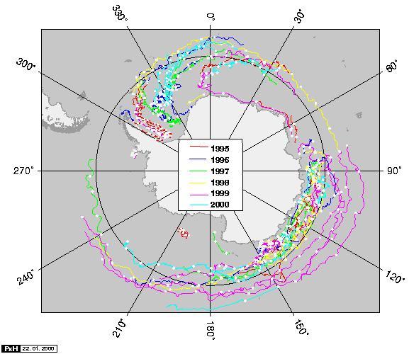
Winds and ocean currents push the buoys around the Southern Ocean. Image courtesy of Petra Heil.
Vicky adds, “[After two months] I flew out to Punta Arenas [Chile]. The camp, including all of the Russians and many of the U.S. scientists, stayed for two more months – four months total.”
WHAT’S IT LIKE TO WORK ON A RESEARCH VESSEL?
Compared to life in the “deep field” (living in tents away from a research station on land – or in huts on an ice floe), everything is very convenient aboard a ship. You have heat, a bunk, a crew to make meals, and the ability to do laundry. You don’t have to carry everything around with you, and you also have a lab, if you need one. Communication has improved significantly, so being on a ship is much like staying at one of the major research stations on the continent. But, there are 150 or so people onboard.
“You don’t have to be best friends but you do need to get along with everyone else,” Vicky said. There are considerations relative to limited space, the uploading and downloading of data, and the timing of data collection, which may be dependent upon the ship’s speed (especially if breaking through the ice). So there are always decisions involved in prioritizing data collection and processing, and of course everyone thinks his or her project is critically important.
Some people can’t do their research while the ship is underway. They travel on the ship but then disembark onto the sea ice for awhile to launch or check instruments and buoys or to physically take measurements away from the ship. They’re working when the ship has stopped.

Scientists preparing their equipment on snow-covered sea ice. Photo courtesy of Vicky Lytle.
Leisure time is enjoyed on these voyages too. When the presence of wildlife or other unique sights was announced, Vicky and the rest of the crew would seize the “Kodak moment.” On some expeditions, for those who don’t usually go out onto the ice, there is planned free time on the ice (sort of like recess) called “Ice Jollies” or “Ice Liberty.” For some, it’s a chance to be away from the constant confinement of the ship and the sensation of ramming the ice and then feeling the ship’s weight break through the ice. Usually someone on a ship has a Frisbee or a soccer ball, and a game is quickly underway. But even an hour spent just standing around on some moving ice is an energizing and awe-inspiring experience! And when “recess” is over, everyone climbs aboard, ready to get back to work.
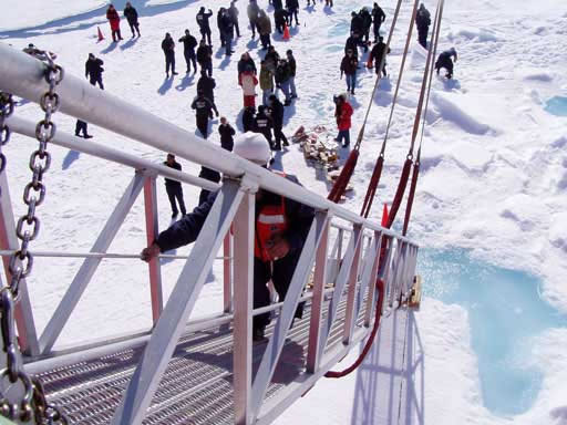
Photo courtesy of HOTRAX: http://sci.odu.edu/oceanography/research/hotrax/.
Vicky Lytle has agreed to respond to questions on the blog. You can hear her explain sea ice from the CReSIS web site (Education – Talk 4 in the workshop links), and download her PowerPoint presentation, too.
This article was written by Carol Landis. For more information, see the Contributors page. Email Kimberly Lightle, Principal Investigator, with any questions about the content of this site.
Copyright October 2008 – The Ohio State University. This material is based upon work supported by the National Science Foundation under Grant No. 0733024. Any opinions, findings, and conclusions or recommendations expressed in this material are those of the author(s) and do not necessarily reflect the views of the National Science Foundation. This work is licensed under an Attribution-ShareAlike 3.0 Unported Creative Commons license.