Despite our tendency to consider Earth as static, it is actually a dynamic and ever-changing planet. Wind, water, and ice erode and shape the land. Volcanic activity and earthquakes alter the landscape in a dramatic and often violent manner. And on a much longer timescale, the movement of earth’s plates slowly reconfigures oceans and continents.
Each one of these processes plays a role in the Arctic and Antarctica. We’ll discuss each in general and specifically in the polar regions.
EROSION
Wind, water, and ice are the three agents of erosion, or the carrying away of rock, sediment, and soil. Erosion is distinguished from weathering — the physical or chemical breakdown of the minerals in rock. However, weathering and erosion can happen simultaneously. Erosion is a natural process, though it is often increased by humans’ use of the land. Deforestation, overgrazing, construction, and road building often expose soil and sediments and lead to increased erosion. Excessive erosion leads to loss of soil, ecosystem damage, and a buildup of sediments in water sources. Building terraces and planting trees can help reduce erosion.
GLACIERS
In the Arctic and sub-Arctic, glacial erosion has shaped much of the landscape. Glaciers primarily erode through plucking and abrasion. Plucking occurs as a glacier flows over bedrock, softening and lifting blocks of rock that are brought into the ice. The intense pressure at the base of the glacier causes some of the ice to melt, forming a thin layer of subglacial water. This water flows into cracks in the bedrock. As the water refreezes, the ice acts as a lever loosening the rock by lifting it. The fractured rock is thus incorporated into the glacier’s load and is carried along as the glacier slowly moves.
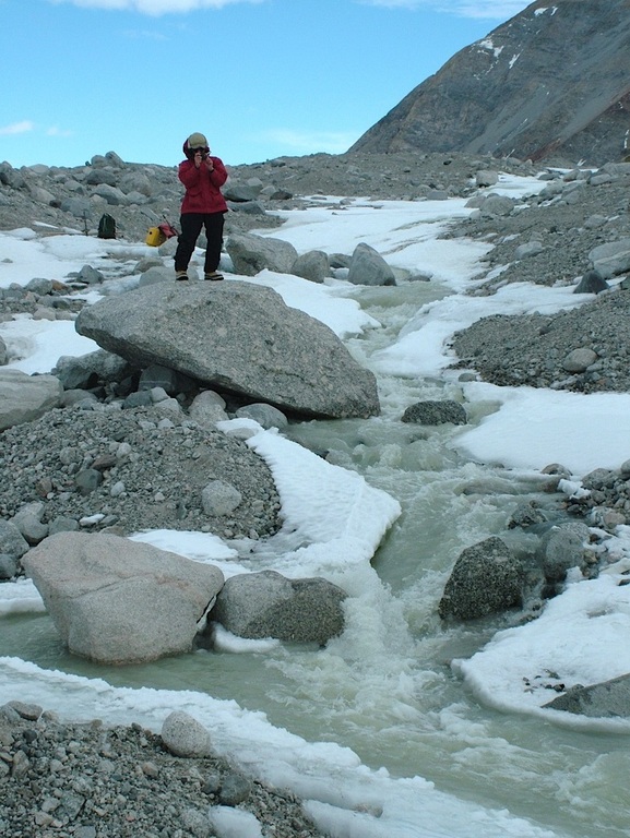
Above-freezing temperatures created a meltwater stream on the Scott Glacier, Antarctica. Photo courtesy of BlueCanoe (Flickr).
Glacial erosion is evident through the U-shaped valleys and fjords that are located throughout the Arctic and sub-Arctic regions. Glacial moraines are formed as a glacier recedes, leaving behind large piles of rock, gravel, and even boulders. Moraines may form at the foot (terminal moraine) or sides (lateral moraine) of the glacier or in the middle of two merging glaciers (medial moraine).
A U shaped Valley in Alaska.
Glacial moraine in Kyrgyzstan.
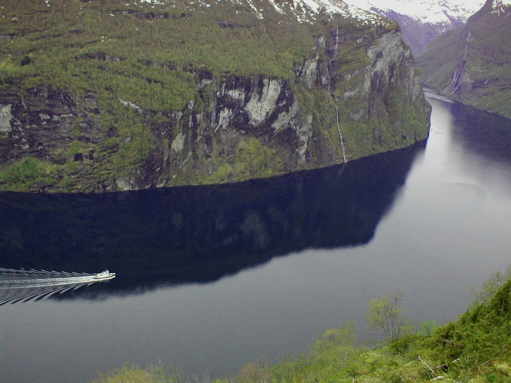
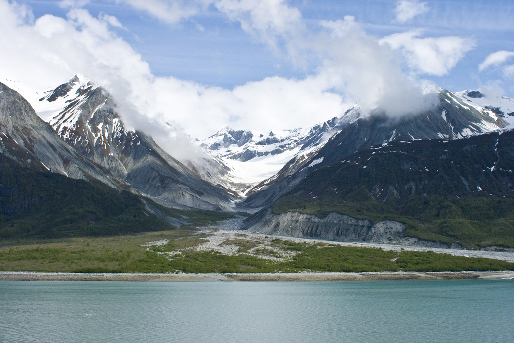
A fjord in Norway.
Photos courtesy (T to B) of Skylar Primm, Geir Halvorsen, and Martin Talbot (Flickr).
Coastal erosion has become a major issue in recent years in the Arctic, with Alaska’s North Slope losing as much as 30 meters (100 feet) per year! Climate change is thought to be the underlying cause. As the climate warms and sea ice melts, more of the sun’s energy is absorbed by ocean water. As this heat is transferred to the land, the permafrost (frozen soil) thaws, making the coast vulnerable to erosion from wave action and storms (which are more frequent due to warmer temperatures and open water). This video from the University of Colorado Boulder and the U.S. Geological Survey shows time-lapse images during one month of crumbling.
WIND
In Antarctica, katabatic winds play a large role in erosion. This type of wind occurs when high-density cold air builds up at high elevations (on the ice sheets, for example) and moves downhill under the force of gravity.

Image courtesy of Hannes Grobe, Alfred Wegner Institute for Polar and Marine Research (Wikimedia).
Katabatic winds in Antarctica and Greenland are intensely cold and fast, often reaching hurricane speed. You can hear these fierce winds in this YouTube video
The winds in Antarctica carry small grains of sand that scour and erode the exposed rocks, resulting in unusual shapes and formations. These oddly shaped, eroded rocks are called ventrifacts.
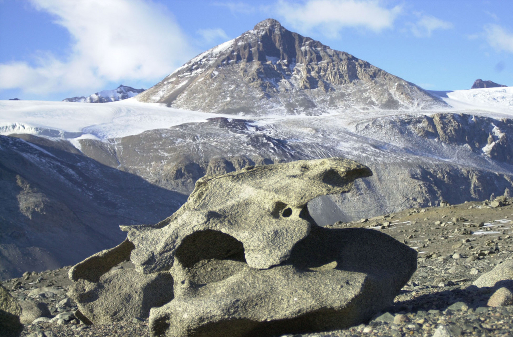
Ventrifacts are wind-eroded rocks found in the McMurdo Dry Valleys. They range from finger-sized to larger than houses. Photo courtesy of Kristan Hutchison, National Science Foundation.
PLATE TECTONICS
The theory of plate tectonics describes the motions of earth’s lithosphere, or outermost layer of hard, solid rock, over geologic time. Plate tectonics provides scientists with a great deal of information about the polar region’s past.
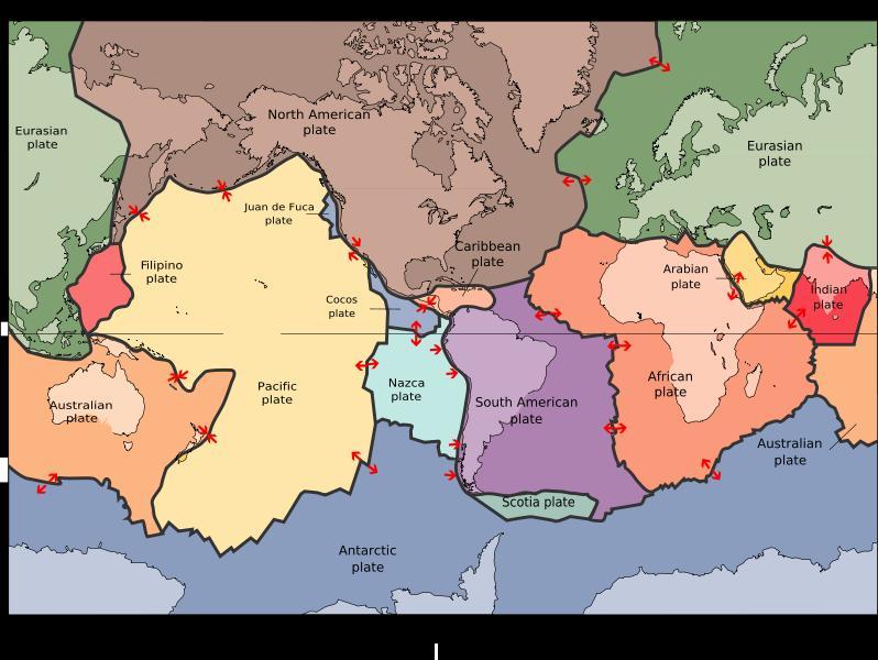
Tectonic plates. Image courtesy of Wikimedia.
Earth’s lithosphere is broken into seven major and many minor tectonic plates. These plates move in relation to each other, slowly changing the location of earth’s continents and oceans.
Geological evidence from Antarctica supports the theory that North America and Antarctica were connected approximately one billion years ago in the global supercontinent Rodinia. The continents eventually broke apart, merging again approximately 200 million years ago in the supercontinent Pangaea. Fossil evidence from this time period confirms that Antarctica was connected to Australia and South America and much warmer than it is today.
The movement of the tectonic plates also means that they are associated with much of the world’s volcanic and seismic activity.
VOLCANOES
A volcano is simply an area where magma, or molten rock, from the earth’s mantle reaches the earth’s surface, becoming lava. Most volcanoes occur at plate boundaries, where two plates are moving away (diverging) or together (converging). A few volcanoes like the Hawaiian Islands form from a hot spot, or a weak spot in earth’s crust, where magma forces its way to the surface.
Volcanic eruptions may be explosive (violent) or effusive (passive), depending on the lava chemistry (amounts of silica and dissolved gases). Silica is a mineral found in nature as sand or quartz. High levels of silica mean very viscous (thick) lava, and low levels mean more fluid lava. Dissolved gases build up inside the volcano, much like a can of soda or other carbonated beverage. The higher the level of gas, the more pressure that builds – and the more violent an explosion. The combination of silica and dissolved gas levels determines the type of eruption and shape of the volcano.
Volcanoes are classified into four types, based on their lava chemistry and shape.
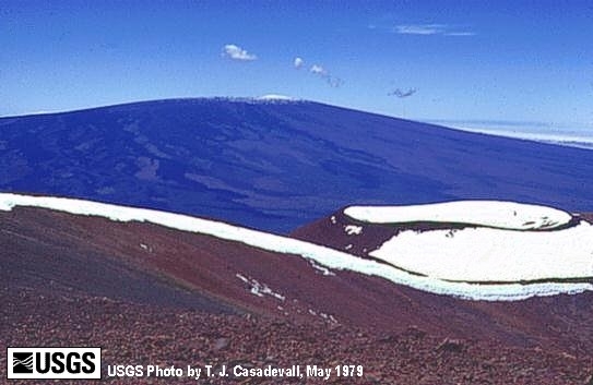 |
Shield Volcano: A shield volcano has low levels of dissolved gas and silica in its magma. Its eruptions are effusive, and the very fluid lava moves quickly away from the vent, forming a gently sloping volcano. Mauna Loa in Hawaii is an example. |
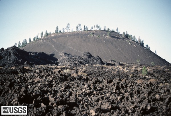 |
Cinder Cone Volcano: A cinder cone volcano has low silica levels and high levels of dissolved gas, resulting in fluid lava that erupts explosively as a result of the immense pressure built in the magma chamber. A cinder cone volcano erupts by shooting fountains of fiery lava high in the air, which cools and forms a steep-sided conical structure. Lava Butte in Oregon is an example. |
 |
Lava Dome Volcano: A lava dome volcano has high silica levels and low dissolved gases in its magma. This results in effusive, viscous lava that forms a rounded, steep-sided mound. Lava domes are often created after an explosive eruption, which released much of the dissolved gas in the magma. The lava slowly continues to flow out of the volcano, forming a rounded, steep-sided mound. Since the 1981 eruption of Mt. St. Helens, a lava dome has been forming inside the crater of the volcano. |
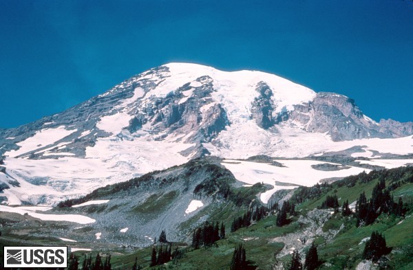 |
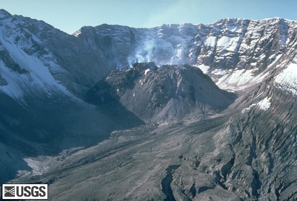
Composite Volcano: A composite volcano has high levels of dissolved gas and silica and erupts explosively. Composite volcanoes often resemble steep-sided mountains before erupting. During violent eruptions, it can seem as if the whole top of the mountain has been blown off. Eruptions often include pyroclastic material (ash and lava fragments), leaving the volcano to collapse inward and form a crater. Mt. St. Helens and Mt. Rainier in Washington are examples. |
Images courtesy of the U.S. Geological Survey.
Largely unexplored, the Gakkel Ridge runs underneath the Arctic Ocean. Scientists have discovered volcanic craters and evidence of surprisingly violent eruptions in the recent past.

Map courtesy of the National Oceanic and Atmospheric Administration.
Antarctica, too, is home to volcanic activity. Ross Island, located in the Ross Sea, is composed of three extinct volcanoes (Mt. Bird, Mt. Terror, and Hut Point) and Mt. Erebus, Antarctica’s most active volcano.

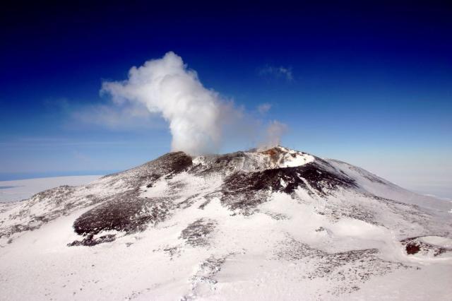
The summit of Mt. Erebus from the front seat of a helicopter. Photo courtesy of Mt. Erebus Volcano Observatory.
Mt. Erebus is home to a permanent lava lake, or a large amount of molten lava contained in a crater. Only three volcanoes in the world have permanent lava lakes, making Mt. Erebus an important research site for scientists looking to better understand the internal plumbing system of volcanoes. However, its location permits only a six-week field season and its high altitude (3794 meters) is physically challenging.
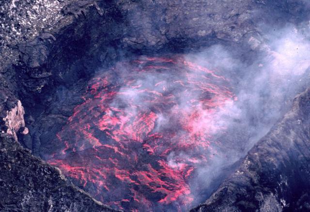
Mt. Erebus lava lake in 1983. Photo courtesy of Mt. Erebus Volcano Observatory.
Mt. Erebus is also notable for its persistent low-level eruptive activity (with almost daily eruptions). While the volcano has had some history of violent activity, most eruptions are passive lava flows similar to the volcanoes of Hawaii.
EARTHQUAKES
Seismic activity (earthquakes) is most often associated with tectonic plate boundaries. As plates slowly move, their jagged edges stick and suddenly slip, causing an earthquake.
The Gakkel Ridge underneath the Arctic Ocean experiences small earthquakes that accompany the volcanic activity found in the area. Antarctica, which lies in the center of a tectonic plate, does not experience many earthquakes. However, seismic activity is associated with eruptions of Mt. Erebus.
RELATED RESOURCES
Use these resources to learn more about erosion, volcanoes, earthquakes, and plate tectonics and how these agents of change affect the polar regions.
All About Glaciers
Learn how glaciers form, move, and shape the landscape.
Katabatic Winds
Basic information about the winds of Antarctica.
National Geographic: Forces of Nature
Explore volcanoes and earthquakes in this web site. Don’t miss the interactive activities that allow you to virtually erupt volcanoes and trigger earthquakes!
Polar Discovery: Arctic Seafloor Expedition
During summer 2007, a team of scientists used autonomous underwater vehicles to explore the Gakkel Ridge. The Polar Discovery web site documents the expedition and provides background information, images, and video.
Mt. Erebus Volcano Observatory
Provides general information about Mt. Erebus, ongoing research, video, and a photo gallery.
National Science Education Standards: Science Content Standards
The entire National Science Education Standards document can be read online or downloaded for free from the National Academies Press web site. The following excerpt was taken from Chapter 6.
A study of changes in the Earth’s surface aligns with the Earth and Space Science, and the Science in Personal and Social Perspectives content standards of the National Science Education Standards:
K-4 Earth and Space Science: Changes in the Earth and Sky
- The surface of the earth changes. Some changes are due to slow processes, such as erosion and weathering, and some changes are due to rapid processes, such as landslides, volcanic eruptions, and earthquakes.
5-8 Earth and Space Science: Structure of the Earth System
- The solid earth is layered with a lithosphere; hot, convecting mantle; and dense, metallic core.
- Lithospheric plates on the scales of continents and oceans constantly move at rates of centimeters per year in response to movements in the mantle. Major geological events, such as earthquakes, volcanic eruptions, and mountain building, result from these plate motions.
- Land forms are the result of a combination of constructive and destructive forces. Constructive forces include crustal deformation, volcanic eruption, and deposition of sediment, while destructive forces include weathering and erosion.
5-8 Earth and Space Science: Earth’s History
- The earth processes we see today, including erosion, movement of lithospheric plates, and changes in atmospheric composition, are similar to those that occurred in the past.
- Fossils provide important evidence of how life and environmental conditions have changed.
K-4 Science in Personal and Social Perspectives: Changes in Environments
- Changes in environments can be natural or influenced by humans. Some changes are good, some are bad, and some are neither good nor bad.
- Some environmental changes occur slowly, and others occur rapidly.
5-8 Science in Personal and Social Perspectives: Natural Hazards
- Internal and external processes of the earth system cause natural hazards, events that change or destroy human and wildlife habitats, damage property, and harm or kill humans.
This article was written by Jessica Fries-Gaither. For more information, see the Contributors page. Email Kimberly Lightle, Principal Investigator, with any questions about the content of this site.
Copyright December 2008 – The Ohio State University. This material is based upon work supported by the National Science Foundation under Grant No. 0733024. Any opinions, findings, and conclusions or recommendations expressed in this material are those of the author(s) and do not necessarily reflect the views of the National Science Foundation. This work is licensed under an Attribution-ShareAlike 3.0 Unported Creative Commons license