Did you know that there isn’t one official definition for the Arctic?
In contrast with the more easily defined boundaries of Antarctica, the southern boundaries of the Arctic vary depending on interest and purpose. According to Rhian Salmon, education and outreach coordinator for the International Polar Year, “there is no official definition of the Arctic for IPY purposes…We accept any definition that works for the [participant scientists], and can also use this as a valuable learning tool about the Arctic, and the complexities of Arctic research.”
This flexibility is interesting but makes it difficult for teachers planning a geography lesson. What, exactly, can be considered the Arctic? We’ve highlighted six common definitions and included corresponding thumbnail images. While these definitions are unique, they encompass very similar areas and the thumbnails look almost identical. Follow the links to the full-sized images to really see the differences!
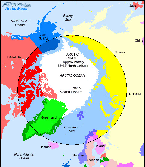
One common definition is the Arctic Circle, the parallel of latitude located at 66.33N. Areas north of this line experience the polar night (a period of 24 sunless hours) and the polar day (a period of 24 sunlight hours) at least once per year. To see the complete version of the following map, click here.
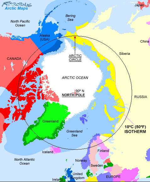
A second definition is the July isotherm. Areas north of this imaginary line do not experience temperatures greater than 10C (50F) in the warmest month of the year. As you can see, the isotherm definition (the highlighted portion of the map) does not correlate exactly to the Arctic Circle definition. To see the complete version of the following map, click here.
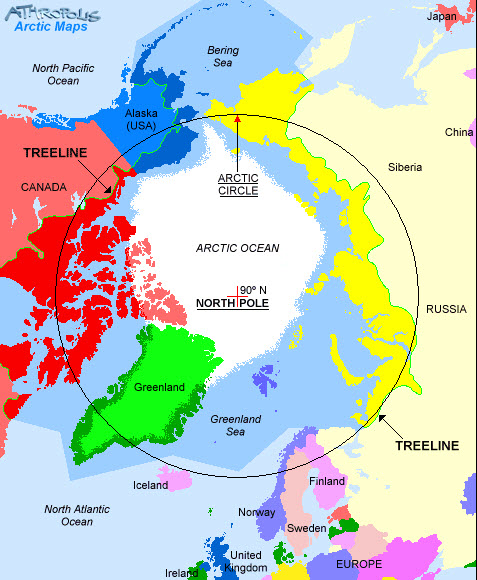
Related to the isotherm is the tree line definition. The tree line roughly correlates to the July isotherm and marks the transition from the forests found in the sub-Arctic to the shrubs and grasses found in the tundra. To see the complete version of the following map, click here.
Another related definition is the extent of permafrost, which is perennially frozen ground. Permafrost only exists in a climate with a mean annual air temperature below 0C (32F). To see the larger version of the following map, click here.
A cultural definition of the Arctic might include the areas inhabited by indigenous Arctic peoples and their traditional hunting grounds. This definition encompasses more area than the Arctic Circle or ecological definitions described above To see the larger version of the following map, click here.

Demography of indigenous peoples of the Arctic based on linguistic groups. Map courtesy of Hugo Ahlenius, UNEP/GRID-Arendal.
Politically, the Arctic includes the territories of the eight Arctic states (United States, Canada, Greenland, Russia, Iceland, Sweden, Norway, and Finland). By other definitions, parts of these territories would be considered sub-Arctic instead of strictly Arctic. To see the larger version of the following map, click here.
The next time you hear or read about the Arctic, remember that there is more than one boundary. Ask yourself which definition of the region is being used?
Though complex and potentially confusing, defining the Arctic is a prime example of the nature and challenges of classification systems. Students tend to view labels as fixed and static, yet these definitions can be flexible, debatable, and ever-changing.
This article was written by Jessica Fries-Gaither. For more information, see the Beyond Penguins and Polar Bears Contributors page. Email Kimberly Lightle, Principal Investigator, with any questions about the content of this site.
Copyright August 2011 – The Ohio State University. This material is based upon work supported by the National Science Foundation under Grant No. 0733024. Any opinions, findings, and conclusions or recommendations expressed in this material are those of the author(s) and do not necessarily reflect the views of the National Science Foundation. This work is licensed under an Attribution-ShareAlike 3.0 Unported Creative Commons license.


