Charles Bentley first worked in Antarctica in January 1957 for the International Geophysical Year (IGY) 1957-58. He has returned to Antarctica in every decade since then. His most recent visit, in January 2010, was to the deep coring site at the West Antarctic Ice Sheet (WAIS) Divide camp. This was preceded by a quick trip to the South Pole Station, where he toured the newly rebuilt station and checked on an innovative astronomy project called IceCube.
Researcher: Charles R. Bentley, geophysicist
University/Organization: Ice Coring and Drilling Services (ICDS), Space Science and Engineering Center, University of Wisconsin-Madison
Research Location: West Antarctica
Charles (Charlie) Bentley is a geophysicist, which means that he studies the physical nature of Earth processes and features. Over his long and distinguished career, he has maintained a primary interest in the West Antarctic Ice Sheet (WAIS). To investigate the properties of the ice sheet, including its thickness and the nature of its bedrock, he has used seismographs to trace sound waves through ice, ice-penetrating radar, and satellite imagery.
Now retired from the Department of Geoscience at the University of Wisconsin in Madison, Charlie continues to serve as the principal investigator for the university’s Ice Coring and Drilling Services (ICDS), which provides support for National Science Foundation (NSF) projects in Antarctica, Greenland, and elsewhere.
International Geophysical Year 1957-58
Charlie had just earned his Ph.D. when he volunteered to lead a scientific expedition, or traverse, from Little America Station to Byrd Station and beyond in Antarctica. A part of the International Geophysical Year (IGY) program, the traverse team was charged with taking measurements as they traveled across the Antarctic ice sheet. The scientists on the team consisted of two glaciologists, who dug snow pits (excavations to reveal layers in the snowpack), and two geophysicists, who took seismic and gravity measurements along the route and determined surface elevations.
The team traveled in a caravan of snowcats (trucklike vehicles that move on tracks), loaded with equipment and supplies. The snowcats were multipurpose vehicles. In the early days, benches in the truck cabs served as a surface for cooking and a place for sleeping, as well as a staging area for the team’s gear during fieldwork. This meant that team members had to move, store, and reassemble items repeatedly. Later, the team added a wannigan (a hut on a sled) to the caravan for cooking and eating activities.
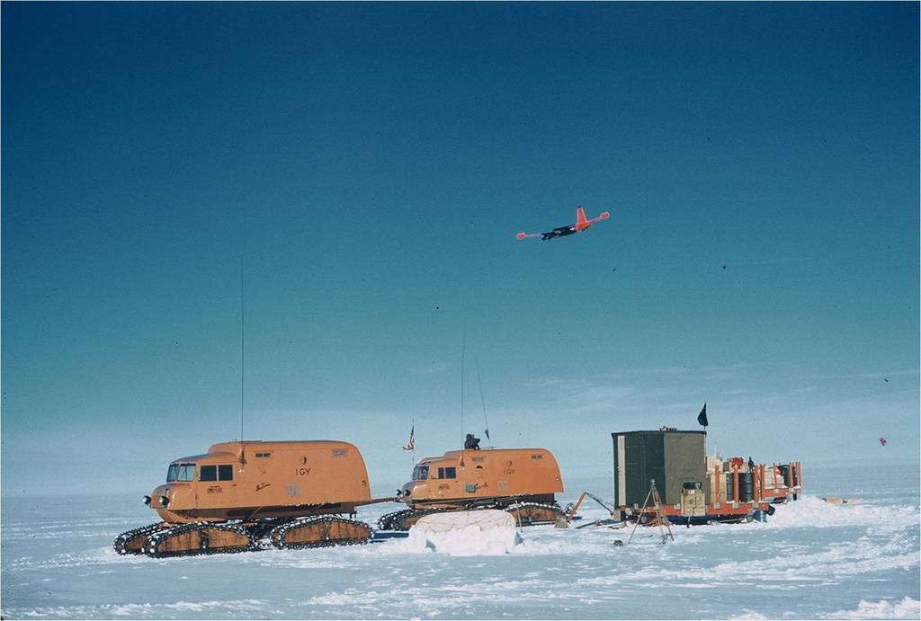
Snowcats ready to go on summer traverse, November 1957. The boxy structure on the first sled is the wannigan. A P2V reconnaissance aircraft flies overhead. Photo courtesy of Charles Bentley.
The team brought along enough durable supplies for the whole trip, but they had to be resupplied with consumables, like bread or gasoline for the trucks, every two to three weeks along the route. Supplies might be delivered in a ski-equipped DC-3 plane, which could land on the ice.
When the team determined that the base of the ice sheet was far below sea level, Charlie became so interested in continuing the research that he volunteered to stay in Antarctica another year! As a result, on his first visit, he spent 28 months in Antarctica before coming back to the States.
Charlie’s 1957-58 traverse team was the first to describe and photograph the Sentinel Range in the Ellsworth Mountains. The northern tip of the range had been recognized and named from the air in 1935, but the main body had not previously been seen, let alone visited, from the surface of the ice sheet! Much of the interior of Antarctica had not been visited by humans, even as late as the 1950s. (Keep in mind that Antarctica is about 1.4 times the size of the continental United States.).
One of the mountains in the Sentinel Range, with an elevation of 4,137 meters (13,573 feet), is named for Charlie – Mount Bentley.
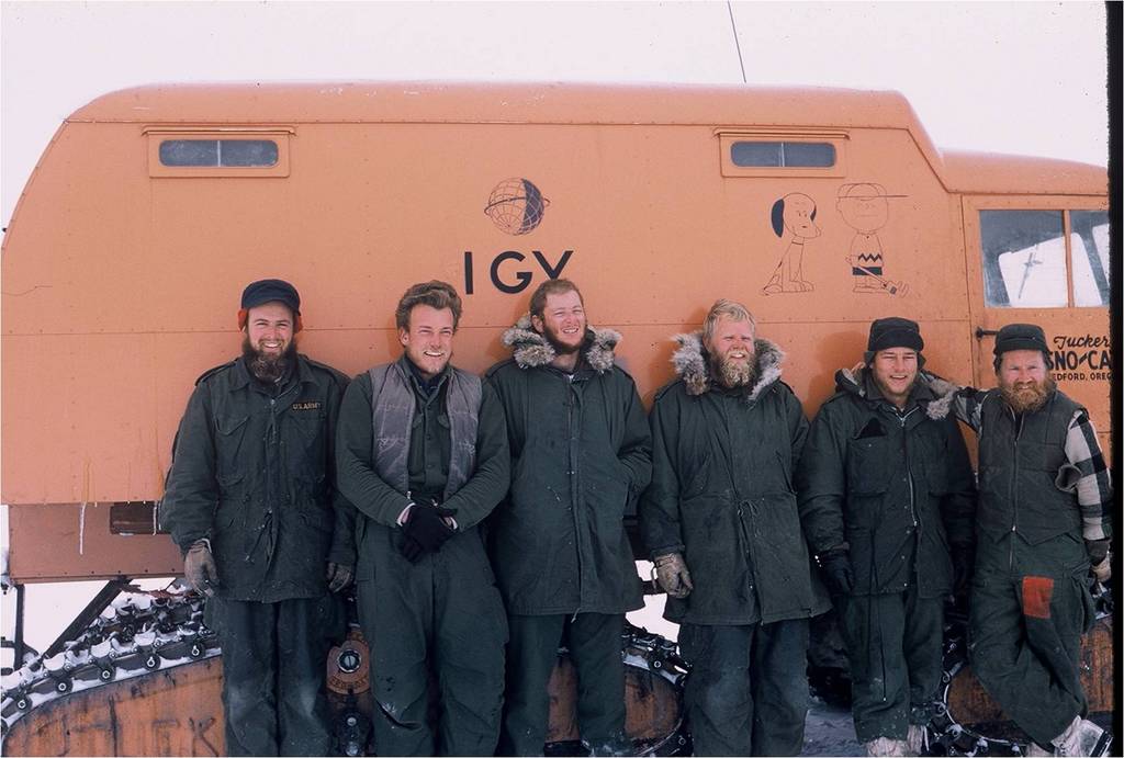
Traverse party in front of one of the snowcats at the end of the 1957-1958 traverse to the Sentinel Range. The clothing is typical U.S. Army issue “summer wear.” Photo courtesy of Charles Bentley.
LIFE ON THE ICE THEN…
During IGY, all scientists working in Antarctica arrived by ship. The timing of arrivals (and departures) was thus determined by the extent of the sea ice surrounding the continent. Teams and supplies could be delayed until the sea ice reached its minimum and the ship could approach the coast. As a result, Charlie and the rest of the team arrived in January 1957 in order to participate in the 1957-58 field season, when they could do fieldwork for three whole months during the austral summer — mid-November through the end of February. This also meant that the team had to winter over in Antarctica.

Byrd Station, about April 1957. The prominent building is the aurora tower; the other red station buildings are barely visible above snow level. Photo courtesy of Charles Bentley.
Radio communications with the rest of the world were spotty, and mail arrived on the first flights to research sites in the spring. In one mail drop, the mail pallet was parachuted down to the team, but the parachute didn’t collapse. Surface winds caught the parachute and dragged it away from the waiting scientists. They pursued it for as long as they could, but they couldn’t catch it. So somewhere out on the West Antarctic Ice Sheet, there’s a buried pallet of letters from home.
In the 1950s, polar scientists were issued extreme cold weather (ECW) gear like that issued to the U.S. Army at the time. It was generally similar to what is given to researchers today. The outer parka, made of a strong fabric with wool inserts for insulation, was heavier than its modern counterpart. However, the truly functional features of the older gear have persisted over the years. For example, the hood of the parka still has an extended, furry ruff to protect the face from the wind.
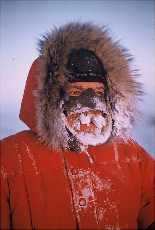
An example of a proper hood (which can be pulled far forward) plus a helpful nose and cheek mask. Photo courtesy of Charles Bentley
Layering has long been understood as the best way to manage warmth. Air-insulated thermal boots, originally designed for use in the Korean War and now called bunny boots, have been modified only slightly since the 1950s. Back then, the scientists were also issued a pair of mukluks (fur-lined boots that may come almost to the knees). Then and now, each scientist arriving for an extended visit to Antarctica was issued a personal, appropriately sized set of clothing, including jackets, overalls, gloves, and mittens.
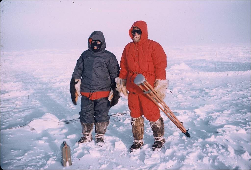
Examples of special IGY clothing. Both men wear caribou-skin mukluks. The man on the right wears dog-skin mitts; the man on the left is wearing bear-paw mitts, which are still issued to this day. The hoods on both men are inadequate — too short and lacking the important fringe. Photo courtesy of Charles Bentley.
Then, as now, scientists working and living away from a research station had to melt snow to have water for drinking, cooking, and personal hygiene. The average temperature in Antarctica is usually below the freezing/melting point. On the traverse, the team used a lightweight stove, called a plumber’s stove, to melt snow quickly. Because Antarctic snow is often quite dry and filled with air, the team often kept some liquid water to use as a starter and make the melting faster.
At Byrd Station, a snow melter was powered by heat from the diesel generator. Everyone took a turn shoveling snow into the opening, depending on how much water he had used. It was just part of daily life at the station. When you used some water, you went out and shoveled awhile.
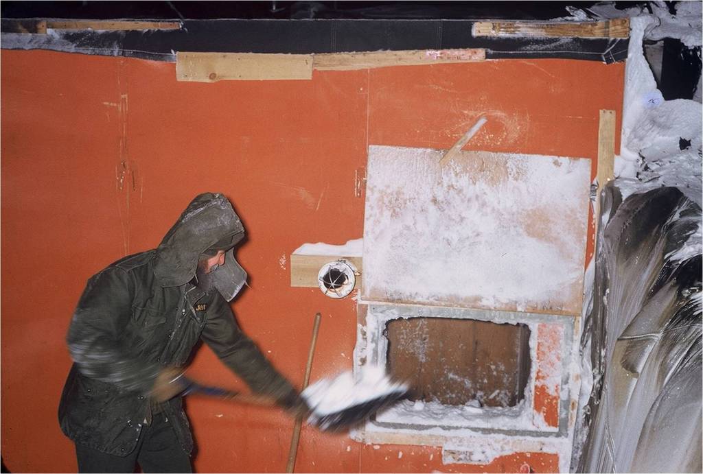
Feeding the snow melter at Byrd Station through a hatch in the side of the generator building. Photo courtesy of Charles Bentley.
Shortly after the IGY ended, the University of Wisconsin began to manage the over-snow traverses. Charlie participated in a traverse in 1960-61 and another in 1963-64, when the research project moved to the South Pole. Bigger snowcats were designed for work on the East Antarctic ice plateau, but the need for traverses diminished rapidly as technology was developed to measure ice thickness from moving aircraft.
…AND NOW
These days, air support is provided to most of the field camps. Materials and supplies arrive by ship, but the scientists can fly to their assigned locations. Traverses are still organized when there is a need to take continuous measurements along a route or to deliver heavy equipment. In addition, a support staff at the field camps handles much of the day-to-day operations, leaving the scientists free to prepare for their fieldwork and data-gathering efforts.
A few advances in clothing and food rations have been developed, but Charlie doesn’t believe there have been significant changes. While the modern ECW clothing is lighter and made with synthetic fabrics, the overall design and function remain the same. Likewise, Charlie reported that the food was good during the IGY. He recalls having frozen vegetables, steaks, egg solids, and dehydrated foods, such as pork chops, that were developed just for the IGY teams.
When asked about the two or three most noteworthy changes since he began his work in Antarctica, Charlie said that satellite observations have truly revolutionized geophysics research. In a similar way, the speed and reliability of communications from the interior of Antarctica to the United States has significantly improved living and working conditions in the field. Finally, the ability to land large transport planes on the ice has also made the delivery of people and equipment to the stations much more efficient.
WORKING AT THE POLE
Charlie said that the primary emphasis for research at South Pole Station is now on astronomy. During the IGY, scientists there studied the ionosphere and aurorae, did some glaciological work, and used seismographs and magnetometers. A seismograph station is still maintained about 7 kilometers (4 miles) from the South Pole. Astronomers working at the Pole have the advantage of continuous solar observations, enhanced by the cold, clear window through the atmosphere. In addition, with modern instrumentation, the telescopes can be operated (literally) from Chicago or other distant control centers.
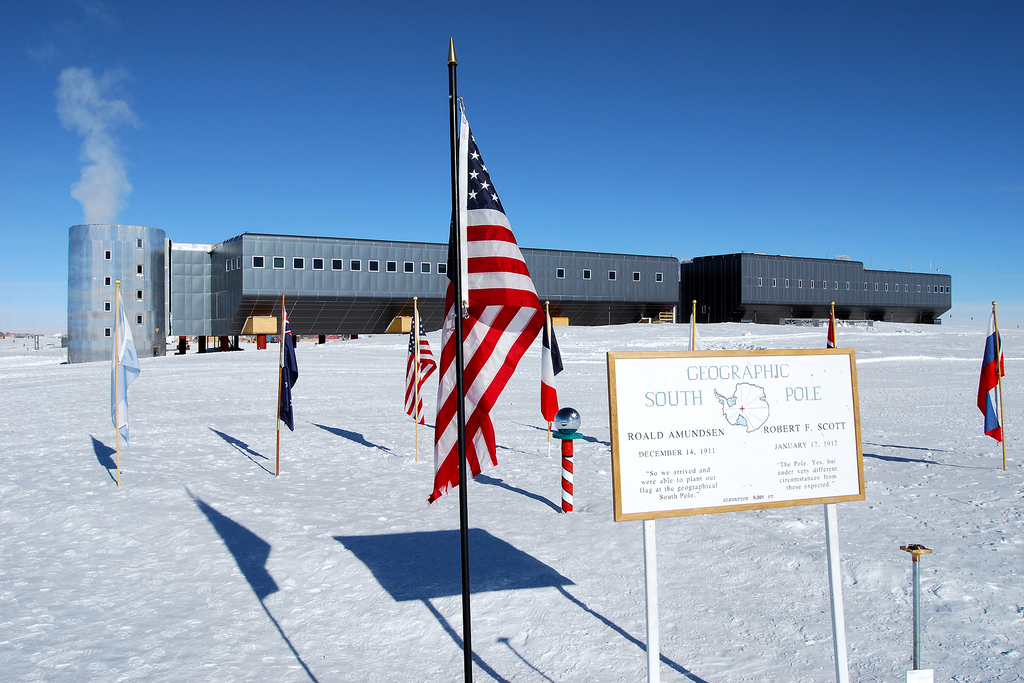
The newly dedicated Amundsen-Scott South Pole Station. Photo courtesy of Dwight Bohnet, National Science Foundation.
This season in Antarctica, Charlie was taking a look at two multiyear projects that ICDS had helped to launch. The WAIS Divide Ice Core project, completing its third season, had reached a depth of about 2,600 meters (8,530 feet), spanning thousands of years of Earth’s history.

The West Antarctic Ice Sheet Divide coring project. The drill shelter is the bigger arch on the left; the lower one on the right, which actually connects to the drill arch, is the ice core processing shelter. Photo courtesy of Jay Johnson, ICDS, 2007.
Earlier, he had gone to South Pole Station to check out the completion of another NSF project, called IceCube, which is searching for neutrinos. That project involved drilling 80 boreholes in a hexagonal pattern through a cubic kilometer of the ice sheet. Strings of 60 optical sensors, lowered into the boreholes, will record data.
Charlie’s work during the 1957-58 IGY and in the 50 years since has been recognized by his peers and colleagues. In 1961, the Bentley Subglacial Trench was named for him. This trench, under the ice east of Byrd Station, is 2,555 meters (8,383 feet) below sea level and is roughly the size of Mexico! Charlie was awarded the prestigious Seligman Crystal by the International Glaciological Society in 1990.
Few scientists have demonstrated such a wide and diversified interest in investigating the ice, snow, atmosphere, and geology of Antarctica.
LINKS
WAIS Divide Outreach
This educational outreach site of the West Antarctic Ice Sheet Divide coring program. It provides multimedia resources that provide an overview of ice coring and how it pertains to the study of climate change.
WAIS Divide YouTube
This video depicts camp life for scientists who are involved with the West Antarctic Ice Sheet Divide coring program.
WAIS Divide Outreach Blog
A blog about the WAIS Divide program.
IceCube
Home of the IceCube project. Includes multimedia, news, and resources.
Ed Outreach for IceCube
The educational outreach site of the IceCube program.
This article was written by Carol Landis. For more information, see the Contributors page. Email Kimberly Lightle, Principal Investigator, with any questions about the content of this site.
Copyright April 2010 – The Ohio State University. This material is based upon work supported by the National Science Foundation under Grant No. 0733024. Any opinions, findings, and conclusions or recommendations expressed in this material are those of the author(s) and do not necessarily reflect the views of the National Science Foundation. This work is licensed under an Attribution-ShareAlike 3.0 Unported Creative Commons license.