
- Leonid Polyak. Photo courtesy of Dennis Darby, Old Dominion University.
Researcher: Leonid Polyak
University/Organization: Byrd Polar Research Center at The Ohio State University
Research Location: Arctic Ocean
As a high school student in his native Russia, Leonid participated in a club for young biologists in Leningrad (now St. Petersburg). Through this organization, he attended a summer camp at the Biological Station of the Zoological Institute of the Russian Academy of Sciences, located on the western coast of the White Sea.
The students assisted staff researchers at the station and did their own summer projects, like collecting and identifying marine animals or conducting lab experiments. Leonid remembers, “The entire setting — gorgeous northern nature, interesting people, first marine experience — was absolutely captivating. So it’s not surprising that many of the kids who participated in that activity took a career that would be related.”
Leonid completed his college studies in Russia, earning a degree in biology from Leningrad State University in 1980 and a Ph.D. in geology in 1985 from Leningrad Mining Institute. His thesis described the types of forams that were present in samples of ocean sediments, identifying those that can be used for understanding how sediments have been formed. Since 1976, he worked on several marine research expeditions for exploration of mineral resources. This onboard experience gave him an opportunity to gather and analyze samples and to formulate his own research questions. “Forams made kind of a bridge between biology and geology for me” he said.
Leonid came to the United States in 1992 and worked for a year at the Woods Hole Oceanographic Institution (WHOI). Then he came to the Byrd Polar Research Center at Ohio State, where he has continued to work with scientists around the world to decipher the history of the Arctic region.
WHAT ARE FORAMINIFERA?
Foraminifera are small marine organisms that live either as plankton afloat in the water or as part of the benthos living among the sediments at the bottom of the sea. They are similar to amoeba (free-form single-celled organisms that are found in fresh water) in that they have membranes that extend outward into the water to provide a surface area for exchange of oxygen and carbon dioxide and to capture smaller organisms as food. However, unlike amoeba, the membranes of forams extend out through holes in a shell, or test (the technical term for internal shells) composed of calcium carbonate crystals or cemented sediment grains.
The tests can be used to identify species of forams. Furthermore, the chemical composition of the tests provides an indication of the temperature and some other properties of the surface water when the forams were alive. When a floating foram dies, its test settles to the ocean floor, contributing to the sediments that accumulate at the bottom. As a result, planktonic and benthic foram tests are both found in seafloor sediments.
Forams offer important clues to past conditions. Analysis of the numbers and types of different species in the sediments as well as the composition of foram tests offers clues about the conditions at the time the forams were alive. From this information, Leonid and his colleagues can determine whether or not the sea surface was likely to have been covered with sea ice. Lastly, foram tests may be used for identifying the age of sediment through their species composition or special analyses such as radiocarbon isotopes.
ARCTIC GEOLOGY
Geologists study all sorts of evidence from rocks, soils, and landforms to understand earth processes and reconstruct earth’s past. Leonid and his colleagues study the conditions in the Arctic Ocean basin so they can better describe climate change in the Arctic over the past several hundred thousand years. They retrieve and analyze samples from the ocean floor, the water beneath the ice, and the ice itself to describe the conditions of the ocean over time.

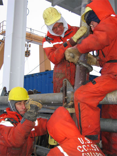
- HOTRAX researchers pull up a sediment core at -10 degrees Celsius. Photo courtesy of Dennis Darby, Old Dominion University.
Arctic paleo-oceanography is a broad field of study. It can include studies of the history of glaciation in the region, the presence and adaptations of life forms, contamination by humans, and the history of sea ice at the surface.
WHY IS SEA ICE IMPORTANT?
Sea ice reflects much of the incoming solar radiation. In contrast, open water absorbs much of the sun’s energy, some of which is then re-radiated back into the atmosphere as heat. As a result, the area of summer Arctic sea ice (called the sea ice extent) is an extremely important factor in predicting the impact of climate change in the region and the world.
Summer sea ice is being lost in the Arctic. Some recent predictions suggest that the Arctic Ocean may be ice-free in summer by as early as 2013. To put these changes in perspective, one big question for paleo-oceanographers and climate scientists is “How did the Arctic Ocean change in the past?” More specifically, a critically important question is “How will the Arctic Ocean behave without a layer of summer sea ice?”
Most recently, Leonid was the lead author on the sea ice chapter of the report for the U.S. Climate Change Program titled Past Climate Variability and Change in the Arctic and at High Latitudes. (Available online at: http://www.climatescience.gov/new.php )
HOTRAX
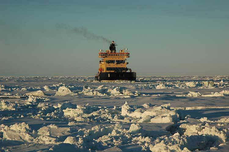
In 2005, Leonid was part of the first successful crossing of the Arctic Ocean for scientific sampling of the seafloor. The expedition was officially named the Healy-Oden TransArctic Expedition (HOTRAX). It was conducted from the U.S. Coast Guard icebreaker Healy and the Swedish icebreaker Oden.

- HOTRAX re
searchers pull up a sediment core at -10 degrees Celsius. Photo courtesy of Dennis Darby, Old Dominion University.
There were two legs of this trip. The Healy spent the first leg north of Barrow, Alaska, in heavy ice. Although it was June, the ice was still thick. In fact, even the icebreaker became stuck in the ice and had to drift for a few days until it could break free. The researchers used this time to test the equipment and train the teams to streamline procedures for data gathering, analysis, and reporting.
During the main leg of the journey, the Healy traveled from the Aleutian Islands in the Pacific Ocean, across the Arctic Ocean and directly over the North Pole, to Tromso, Norway, in the North Atlantic Ocean. Most of the travel across the central Arctic Ocean was conducted by the Healy and the Oden together, which made the passage easier. During the two legs, researchers retrieved sediment cores from 29 sites and gathered over 1,000 feet of core material, which is maintained in a refrigerated storage facility at the Byrd Polar Research Center.
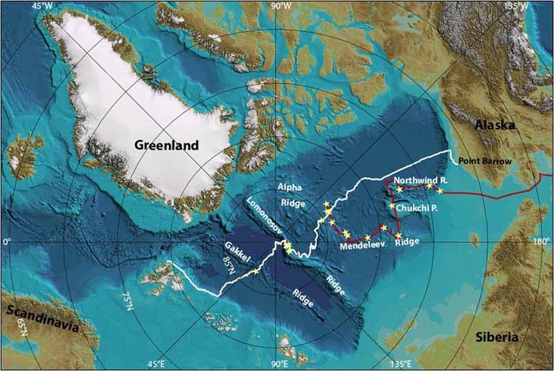
Map of the HOTRAX transect (a line for scientific measurements) across the Arctic Ocean in 2005. The red line marks the path of the U.S. Coast Guard Cutter Healy before the two ships met, and the white line the path of the Swedish icebreaker Oden and two ships together. Yellow stars mark the sites where sediment cores were taken from the bottom of the ocean. Depths are based on the International Bathymetric Chart of the Arctic Ocean (IBCAO, www.ibcao.org). Image courtesy of Martin Jakobsson, Stockholm University.
A WET AND COMPRESSED HISTORY BOOK
Seafloor sediments are complicated recorders of Earth’s history. Unlike ice cores, which have annual layers because of seasonal accumulation and which can be dated accurately to a decade or year, the rate of accumulation of Arctic seafloor sediments can be very low. As a result, annual layers are not typically detectable. Instead, analyses are more likely to be described on time scales of decades to millennia.
The central Arctic Ocean has been the focus of recent international expeditions because it contains a good record of sediments deposited over the last 100,000 years. Data from this time frame will help the scientists to understand what happened during the warmer periods of earth’s recent past and offer clues to our future.
Sediments from the Arctic Ocean floor typically show distinct color banding, within time frames of several thousand years. The darker, brown color bands are associated with warmer conditions. This color is dictated by higher levels of manganese…presumably originating from Siberian rivers. Lighter colored, manganese-poor bands indicate periods with more severe ice and temperature conditions. Although the correlation of this banding with manganese content is well documented, researchers do not fully understand the mechanisms involved. The study of seafloor sediments clearly requires an interdisciplinary approach.

- Leonid and Dennis Darby describe a sediment core. Color banding is clearly visible. Photo courtesy of Dennis Darby, Old Dominion University.

OTHER KINDS OF DATA
Forams are only one part of a suite of evidence that is used to determine when open water was present and when the Arctic was covered by ice. Paleo-oceanographers also study the mineral nature and chemistry of the sediments and the morphology or form of the seafloor itself.
For example, one of Leonid’s colleagues, Dennis Darby, from Old Dominion University, studies sediments embedded in the ice to determine how and where rock and soil sediments originated and were transported. On the 2005 expedition when the ship was stopped, Dennis and his team would go onto the sea ice to take samples of sediments that were being carried, called “ice-rafted,” on the surface of the ocean. As the ice travels, some of the sediments drop out and settle to the seafloor, providing a record of the ice movement.
 Ice-rafted debris from land is carried away from shore by moving sea ice. Mineral composition and other clues give scientists an opportunity to assess the path that these sediments have taken. Photo courtesy of Dennis Darby, Old Dominion University.
PROCESSING THE CORES
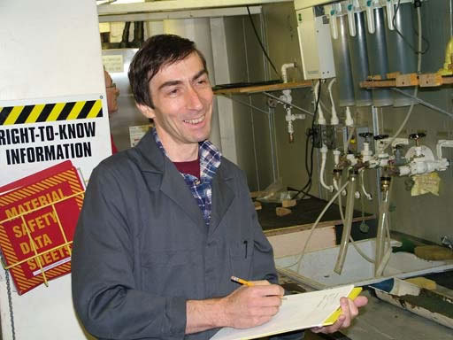
Graduate students who work with Leonid help by sampling the cores and washing the forams out of the sediments. They assist with counting, identifying, and photographing the shells.

- Studying foram shells. Photo courtesy of Carol Landis.


- Photo courtesy of Carol Landis

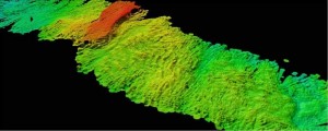
Some other findings from these Arctic expeditions include the discovery of long, parallel gouges and other abnormal topographies in the seafloor. These features clearly demonstrate that large masses of very thick ice were being dragged or pushed around the Arctic Ocean, possibly propelled by gigantic ice sheets that formed in North America and Eurasia during Pleistocene glacial periods. Another intriguing fact that was picked up by analysis of sonar data from the vessels was the discovery of large mud waves in the Arctic basin, where water circulation is generally believed to be only sluggish.

- Sonar image of the Arctic Ocean floor, showing very large parallel gouges carved by long-ago glaciers. Image courtesy of Martin Jackobsson, Stockholm University.

Another intriguing discovery in the Arctic Ocean basin, which was picked up by analysis of sonar data from the ships, was a large mud wave caused by water currents. Until now, the Arctic had been thought to be too shallow for this type of feature to develop.
- Sonar image of the Arctic Ocean floor, showing a wavy surface caused by water currents. Image courtesy of Martin Jackobsson, Stockholm University.

From a scientific research perspective, less summer sea ice in the Arctic Ocean will mean a longer season for exploratory expeditions and r
educed need for ice breakers. Researchers may be able to conduct additional transects and enhance the collection of sediment cores from other parts of the basin. Answers to some of today’s questions will raise other questions, and changes in the Arctic Ocean are clearly “uncharted territory” from the climate perspective.
This article was written by Carol Landis. For more information, see the Contributors page. Email Kimberly Lightle, Principal Investigator, with any questions about the content of this site.
Copyright May 2009 – The Ohio State University. This material is based upon work supported by the National Science Foundation under Grant No. 0733024. Any opinions, findings, and conclusions or recommendations expressed in this material are those of the author(s) and do not necessarily reflect the views of the National Science Foundation. This work is licensed under an Attribution-ShareAlike 3.0 Unported Creative Commons license.