The ever-present plume from Mt. Erebus appeared in the background of my photos and caused me to question what I’d learned about volcanoes. It was December 2003, and I was a teacher who was fortunate to be at McMurdo Station, on Ross Island, Antarctica, at the same time as two volcanologists who were happy to answer my questions. Now, almost five years later, one of those volcanologists, Hubert Staudigel from the Scripps Institution of Oceanography, has returned to Antarctica with a different purpose.
Researchers: Hubert Staudigel and Cathy Constable
University/Organization: Scripps Institution of Oceanography at the University of California, San Diego
Research Location: Mt. Erebus, Antarctica
The plume of steam from Mt. Erebus typically drifts silently upward and then is carried aside by the winds. Few people would correctly guess the wind and temperature conditions that are typical at that elevation. It can be a harsh and unforgiving environment to work in. Huts provide shelter and a place to eat so that scientists can spend more time near the crater. At the same time, cameras continuously monitor the activity in the crater. (Selected movies and videos are available online at http://www.youtube.com/view_play_list?p=0ADEB8D48081768F.)
In 2003, Hubert and his colleague, Cathy Constable, were at McMurdo Station for their first study of the volcanic history of Mt. Erebus and the McMurdo Sound region. The day that I interviewed them, they had completed the necessary survival and skills training but were waiting for better weather to begin their research. They used this time to study photographs taken from a helicopter trip the day before to identify suitable sampling sites in the region.
They planned to collect about 70 rock samples. If it went well, they hoped to be finished in ten days…ten really good days. “We’ll have to see how the weather works with us. It’s the most important member of our party,” Hubert said. “The rim of the volcano can be really inhospitable. The winds are horrific. You cannot work when it’s really windy and cold. You just have to wait it out.”
He added that Mt. Erebus is a fantastic lab for volcanologists. It has sequential layers of rock on its flanks, but the area is also surrounded by many other lavas Hubert and Cathy could sample. Ross Island has three extinct volcanoes, and others are nearby on the mainland — in the Royal Society Range and the McMurdo Dry Valleys.
WHAT DO WE KNOW ABOUT MT. EREBUS?
Sir James Clark Ross, a British naval officer and explorer, discovered Mt. Erebus during an eruption on January 27, 1841. He named it and a nearby volcano after his two ships, Erebus and Terror.
Mt. Erebus is the largest active volcano and the second tallest volcano on Antarctica, with a summit elevation of 3,795 meters (12,451 feet). It is the highest point on Ross Island, home to both the U.S.-operated McMurdo Station and New Zealand’s main research station, Scott Base. Erebus is tall enough to be classified as an “ultra,” meaning that its summit reaches more than 10,000 feet above sea level. Mt. Sidley, whose summit reaches 13,717 feet above sea level, is the only Antarctic volcano taller than Mt. Erebus.
The upper part of Mt. Erebus is a stratovolcano (made of many layers of igneous rock from eruptions) on top of a lower shield structure. The volcano is a little over a million years old, but the upper portion is less than 100,000 years old.
Mt. Erebus has an outer crater about 650 meters (2,132 feet) wide that forms a distinct ring at approximately 3,200 meters of elevation, and an inner crater about 250 meters wide and 100 meters deep (820 by 328 feet) within which is an active lava lake. The volcano has been continuously active since 1972. The lava lake is red-hot molten rock, as can be seen in the close-up photo above and the NASA image below.
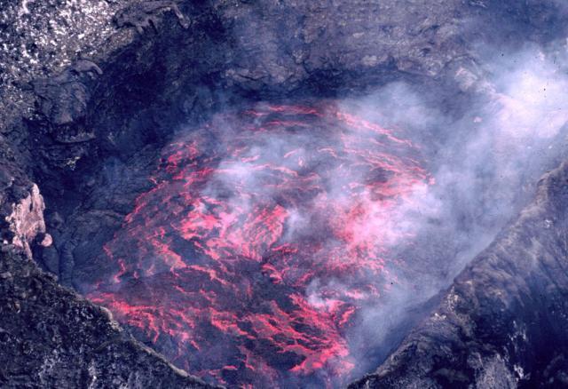
Mt. Erebus lava lake in 1983. Photo courtesy of Mt. Erebus Volcano Observatory.
One of the fascinating facts about Mt. Erebus is that layers of ice have been found between the rock layers. This means that eruptions occurred that did not completely melt through the glacial ice.
LAVA AND THE EARTH’S MAGNETIC FIELD
Cathy, a geophysicist, was refining a model to explain how the earth’s magnetic field reverses from its “normal” position (today’s north and south) to the “reverse” (south becomes north). She and Hubert had been to Spitsbergen (Norway) and to the Azores and Canary Islands in previous years. They had also visited Costa Rica, where modern volcanoes erupt because of the subduction of an oceanic plate under continental crust. They were seeking evidence that the earth’s magnetic pole literally migrates from north to south when the reversals happen. The trip to McMurdo and Mt. Erebus enabled them to gather data from “recent” volcanic sites nearer to the South Pole.
Lava is the perfect recorder of the earth’s magnetic field. All magmas have enough iron-bearing minerals to detect the earth’s magnetic field. The minerals in the lava align themselves toward the earth’s magnetic field as the lava freezes. As a result, the magnetic field of that day is recorded when the lava hardens.
The most compelling evidence for the earth’s polar reversals was found in measurements of the magnetic field taken from ships traveling over the mid-ocean ridge system. Those observations resulted in the graphic below that illustrates normal and reversed polarity in the rock layers. This evidence was fundamental to the acceptance of the theory of plate tectonics, which explains the changes in the position of ocean basins and continents driven by movements of the fluid materials in the earth’s interior.

This graphic illustrates the “stripes” showing reversed polarity in the rocks of the seafloor on either side of the mid-ocean ridge system. A is the spreading of new ocean crust about 5 million years ago, b about 2 to 3 million years ago, and c at the present time.
Cathy described magnetic reversals as being like “weather in the core.” They occur at very irregular intervals. One model says that they happen randomly. The rate at which reversals occur seems to be 4-5 times per million years…but there hasn’t been a reversal for almost a million years. “By that token, we’re overdue,” she said. However, she has since published an article (2006) explaining evidence that earth is not in the process of reversing its polarity at this time.
READING THE DIARY OF MT. EREBUS
Volcanoes are both a productive and destructive force on earth. They deliver and distribute rock material from the earth’s mantle upward, creating new crust and developing new rocks and landforms on the continents. But they also result in destruction of existing areas, as red-hot lava and ash combine with the force of gravity to cover and disturb ecosystems.
Volcanoes also provide a diary of earth’s past, offering many types of evidence about both the position of the continents and the time frames during which activity occurred. The types and distribution of materials that were ejected and the frequency with which eruptions occurred are important data needed to reconstruct a volcano’s history. Whether the volcano exploded or had a quieter lava-flow eruption, the layered material offers a relative measure of time, indicating what features were there at the time of the eruption.
Making good observations about today’s active volcanoes helps scientists to interpret the pieces of evidence that they find in the rock record about earth’s past. For example, scientists have detected a change in the chemistry of the lava from Mt. Erebus by sampling rock formations on the flanks of the mountain and by analyzing tephra (air-borne solid materials ejected by the volcano). To do this, they drill into the rocks and send the cores back to the lab for analysis. For the data to be useful, scientists need to keep detailed records of the original locations and positions of the cores.
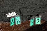
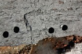
Hubert Staudigel’s team found a low-tech but handy way to label drill holes at sampling sites — the site numbers were written on tan-colored “white” board with a dry-erase pen and the hole letters on labels attached to giant paperclips stuck into the holes. The photo on the right shows the drill holes without labels.
Photos by Hubert Staudigel at http://earthref.org/ERESE/projects/GOLF182/.
The nature of any volcano can be assessed by analyzing the type of cone, the size of the crater or caldera, the types of lava that are discharged, and the area that is covered. Based on what is known, Ross Island and the volcanoes associated with it are thought to have formed over a plume or “hot spot” in the earth’s mantle.
Using analyses of rock samples and maps of visible features, scientists have developed a theory about the formation and evolution of Mt. Erebus. The existing model shows that a cone formed on a shield volcano (volcano with sloping sides) between 1.3 and 0.7 million years ago. The summit of this volcano collapsed at some time during the next 350,000 years, resulting in the formation of Fang Ridge.
Over the next 100,000 years, the chemical composition of the lava changed and the site of eruptions shifted to one side of the volcano. Those eruptions continued for the next 160,000 years, building a cone that subsided sometime between 90,000 and 70,000 years ago and left the caldera that is easily seen from photos. For the past 70,000 years, eruptions at the summit and along the flank have continued to build the cone. The age of the present cone at the summit is estimated to be less than 1,000 years.
STUDIES ABOUT MODERN MT. EREBUS
A team of scientists led by Philip Kyle, from the New Mexico Institute of Mining and Technology, has been studying the modern activity of Mt. Erebus. In 1993 the team updated some of the equipment that had been deployed and began a more detailed study of the gases emitted from the crater. Since 2000, a camera has been aimed at the lava lake, recording the action below. The Mt. Erebus Volcano Observatory web site offers a photo gallery as well as graphed data and maps for the day-to-day activity of earth’s southernmost active volcano.
Recently, modern instruments have been put in place to improve data collection. In addition to monitoring the seismic activity (earthquakes and ice quakes) associated with the volcano, other data are being gathered as well. Those data include: tilt of the sides of the mountain; Global Positioning System (GPS) coordinates for features on the mountain; infrared (heat) energy; infrasound (beneath the lower limit of human hearing); meteorological or atmospheric studies; and the chemistry of released gases.
MORE THAN JUST THE ROCKS
Mt. Erebus and other volcanoes are also interesting from the perspective of how they change the conditions for life. Hubert Staudigel and his colleagues are back in Antarctica to investigate the base of the food chain in the extreme environment of the McMurdo area around Ross Island, as a possible indicator of conditions that may exist on other planets or that may have been present during the early part of earth’s history. Specifically, they hope to learn how microbes make organic carbon using inorganic components from the environment and which microbes are able to use chemical energy and nutrients from rocks and soils that are predominantly made of inorganic substances.
Reference
Constable, C., and M. Korte. 2006. Is Earth’s Magnetic Field Reversing? Earth and Planetary Science Letters, 246(1-2) 1-16. 15 June 2006.
This article was written by Carol Landis. For more information, see the Contributors page. Email Kimberly Lightle, Principal Investigator, with any questions about the content of this site.
Copyright December 2008 – The Ohio State University. This material is based upon work supported by the National Science Foundation under Grant No. 0733024. Any opinions, findings, and conclusions or recommendations expressed in this material are those of the author(s) and do not necessarily reflect the views of the National Science Foundation. This work is licensed under an Attribution-ShareAlike 3.0 Unported Creative Commons license.